
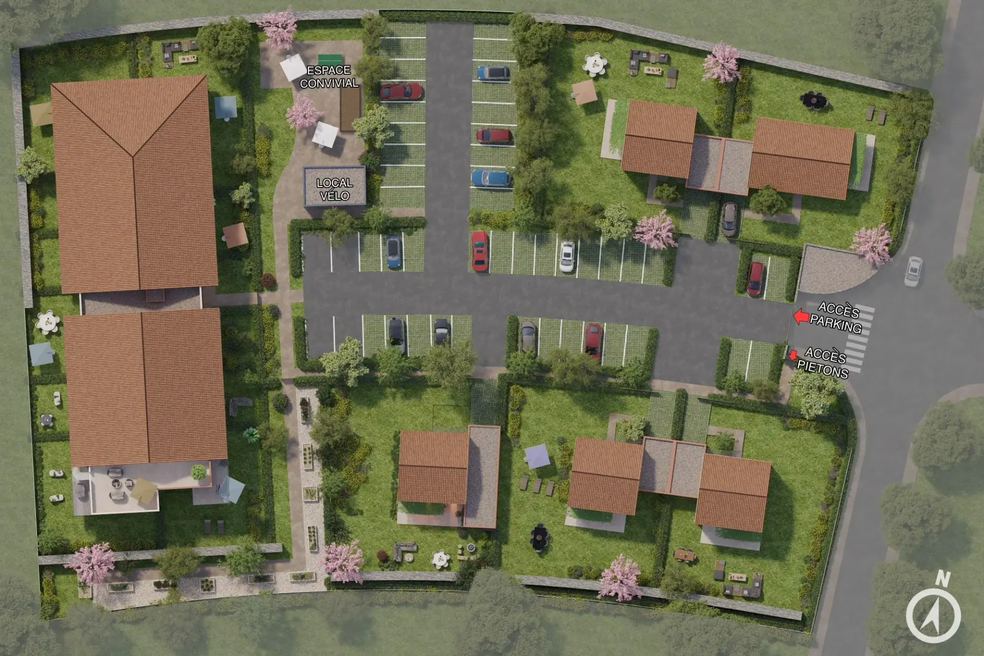
3D site plans to present your entire development
Buildings, access, parking and landscaping: show how the project fits together. Provide an overview for locating units and supporting sales presentations.
Aerial 3D view of a real-estate development showing the layout of buildings, access points and the site's landscape.
A 3D site plan makes the overall layout of a real-estate development readable: building positions, access, parking, circulation and green spaces. It is useful for permit applications, competitions and public consultation as well as for a development page or a sales meeting. Vizion Studio delivers a well-framed 3D site plan in 3 to 5 days.
6 site plans delivered
Each slot shows a real 3D site plan, produced for a complete development.
What you receive
An overview modelled from site drawings and available documentation.
A representation of agreed buildings, access routes and outdoor spaces.
A presentation image for marketing materials and project meetings.
Scope agreed before production
The area covered, landscape detail, labels and file formats are defined before production.
Materials tailored to your role
Property developers
Present a residential or commercial development before completion. We define the views and materials needed for your launch, sales meetings and individual units.
Choose your property sales materialsArchitects and project owners
Make volumes, materials and the project’s surroundings easier to understand. Viewpoints are based on your plans to help explain the architectural intent.
Prepare your architectural briefReal estate communication agencies
Use 3D deliverables across your campaign: development websites, brochures, signage and digital media. Formats and reviews are agreed with your creative team.
Plan your campaign deliverablesFrom brief to ready-to-use materials
Four stages, with scope and timing agreed together.
- 01
Brief and documents
Share available plans, objectives, required materials and your schedule.
- 02
Scope and quotation
We define deliverables, viewpoints, formats and review stages.
- 03
Production and reviews
We produce proposals and incorporate the agreed feedback from your team.
- 04
Delivery and distribution
Receive approved materials in the formats planned for your marketing.
3D site plan, orbital model, rendering or film?
Each asset offers a different level of reading. Here's the one to favour according to your presentation objective.
The highlighted column is the clearest asset to explain a development's overall layout.
| 3D site plan | Orbital model | 3D rendering | 3D animation film | |
|---|---|---|---|---|
| Understanding the layout | Very high | High | Medium | Good |
| Interactivity | None | Full (360°) | None | None |
| Main use | Permits, competitions, sales | Web exploration | Visual showcasing | Marketing storytelling |
| Production time | 3 to 5 days | 10 to 20 days | 3 to 5 days | 20 to 30 days |
| Ideal use | Overview | Interactive project | Key angle | Video campaign |
Practical guidance
Prepare your 3D project
Real-Estate 3D Marketing: A Visual Toolkit for Developers
A developer's guide to real estate 3D marketing: every CGI asset, what each one sells, and how to combine property marketing visuals across the funnel.
Read the guideOff-Plan CGI: How 3D Renders Sell Property Before It's Built
Off-plan CGI lets developers sell property before it's built. Here's how pre-construction 3D rendering wins buyers, funds launches, and reduces sales risk.
Read the guide
Before starting your project
Which deliverables are included in the quotation?
The area covered, landscape detail, labels and file formats are defined before production.
What budget should I allow for this 3D service?
The budget depends on the number of deliverables, project complexity, level of detail and distribution channels. Share your requirements and documents for a quotation based on the actual scope.
Which documents are needed to start?
Send available plans, material and design references, required views or spaces and your target date. If the brief is incomplete, we will identify the missing information during scoping.
How are timing and reviews organised?
We agree a schedule after reviewing the brief, separating first proposals, your feedback and final delivery. Changes to plans or scope may require a revised schedule.
How does this differ from other 3D services?
This 3D site plan is a presentation illustration. It does not replace the regulatory drawings required for planning applications.
How can the deliverables be used and updated?
Formats, permitted uses and any hosting arrangements are specified in the quotation. Tell us about planned updates or variations so we can account for them in the scope.
Let’s discuss your property project
Tell us about your development, the materials you need and your schedule. We will define the deliverables and quotation with you.