
3D renderings in Tours: marketing a new-build development in the Loire Valley
Tours market, protected heritage area, ABF approval, tufa and slate: what a 3D rendering must reflect for a new-build development in Tours, France.
By David Dana
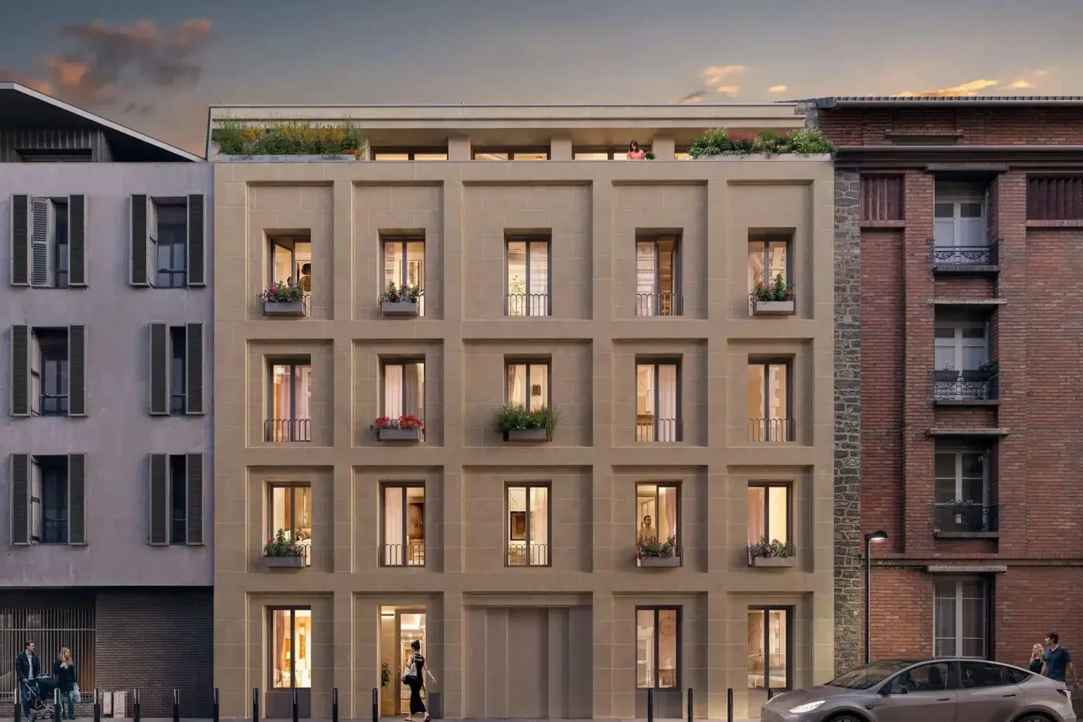
In short: in Tours, a 3D rendering of a new-build development must first reflect the local framework: a historic centre covered by one of the largest protected heritage areas (site patrimonial remarquable) in France, the approval of the Architecte des Bâtiments de France (ABF) within that area and around historic monuments, and a tufa-stone and slate architecture that the images must render accurately. It then supports a pre-sales period that, in the Tours market, remains long.
Ordering 3D renderings for a development in Tours or its metropolitan area is not just about producing attractive images. It means showing a building that does not exist yet in a city where new construction is closely regulated, to buyers who reserve off-plan (VEFA), sometimes long before work starts.
This guide is for developers, architects and sales teams preparing a project in Indre-et-Loire. It covers the local new-build market, the heritage rules to build into the very first view, the materials to get right and the views to plan, from building permit to sales.
The Tours new-build market: a long pre-sales period
According to the Ocelor observatory's market note for the third quarter of 2026, the Tours area recorded 127 reservations for 77 homes put on sale, with 693 homes on the market and a 17-month absorption rate. Investors accounted for 46.5% of the quarter's reservations. Ocelor's president also notes that weak unit-by-unit sales hold back the start of projects, because the pre-sales period is too long (Ocelor, Q3 2026, consulted on 10 November 2026).
For sales material, this has two consequences:
- images must last: a rendering seen on the site hoarding, the brochure and the development website for many months must stay faithful to the project and consistent from one medium to the next;
- they must speak to several audiences: a buyer who will live in the home looks for atmosphere and a view, while an investor mainly wants to locate the development, understand the unit type and judge the quality of the address.
Building in Tours: a heritage framework to include from the first view
One of France's largest protected heritage areas
The Tours conservation area (secteur sauvegardé) was created in 1973 and revised in 2013. It runs from Vieux Tours to the cathedral quarter and now covers 150 hectares, making it one of the largest in France; since the 2016 LCAP law, conservation areas have been called sites patrimoniaux remarquables (City of Tours, "Tours au fil de la ville" heritage trail, consulted on 10 November 2026).
Its conservation plan (PSMV) sets rules on height, massing, materials and colours that also apply to new buildings (City of Tours, "Tours, la demeure urbaine" heritage trail, consulted on 10 November 2026). A rendering of a project within this area must therefore show the exact heights, roof pitches and colours approved, not an embellished version.
Approval by the Architecte des Bâtiments de France
In a site patrimonial remarquable, works permits require the approval of the Architecte des Bâtiments de France (ABF), who has two months to respond on a building permit; without that approval, the permit cannot be granted (French Ministry of Culture, works in a site patrimonial remarquable, consulted on 10 November 2026). Outside that area, the same rule applies to buildings in view of a historic monument and within 500 metres of it, where no specific perimeter has been defined (French Ministry of Culture, works near a historic monument, consulted on 10 November 2026).
The Ministry adds that the ABF can be consulted on a preliminary design. Street-level site-integration views, produced early, support that discussion: they show the project in the real street, next to the neighbouring buildings.
The Loire Valley, a World Heritage site
Tours is one of the towns of the Loire Valley between Sully-sur-Loire and Chalonnes, inscribed on the World Heritage List in 2000. UNESCO lists tufa and slate architecture among its features (UNESCO, The Loire Valley between Sully-sur-Loire and Chalonnes, consulted on 10 November 2026).
A municipal plan, pending the metropolitan plan
Outside the historic centre, the municipal local plans (PLU) apply. The metropolitan plan (PLUm), which will eventually replace the plans of the 22 municipalities of Tours Métropole Val de Loire (City of Chambray-lès-Tours, PLUm, consulted on 10 November 2026), is still being prepared: the draft is now expected at the end of 2026 or early 2027, with entry into force at the end of 2027, and until then municipal plans continue to apply (City of Saint-Avertin, PLUm, consulted on 10 November 2026). The rules to depict are therefore those of the plan in force on the filing date, to be checked with the project architect.

Tufa, slate and neighbours: what the image must get right
In Tours, a rendering is judged on how faithful it is to materials and on how the building relates to its neighbours. The City notes that the post-war Reconstruction of the centre sought harmony with the old buildings through dressed-stone façades and slate roofs, and that recent buildings in the centre face both Reconstruction-era and medieval housing (City of Tours, "Tours, la demeure urbaine"). The same document cites the Deux-Lions and Monconseil districts as mixed-use developments.
For the image, this means a few concrete requirements:
- stone colour: tufa that is too white or too yellow stands out at once; it is matched to samples or to photos of the neighbouring façades;
- slate: its blue-grey colour and the roof pitches must match the plans and the surroundings;
- neighbours: existing buildings are shown accurately, at the right height, rather than erased to make room for the project;
- light: soft late-day light flatters pale stone, provided it stays credible for the site and orientation.

Which views to plan for a development in Tours?
The choice of views depends on the site. A project in the historic centre and a scheme in the inner suburbs do not call for the same images:
- in the historic centre or near a monument: eye-level views from the public space, showing the project between its neighbours; these are the views that support the discussion with the ABF and the permit's site-integration document;
- in a courtyard block: a view from the garden or courtyard, showing what cannot be seen from the street;
- in the surrounding municipalities: an aerial view or a 3D site plan to explain the layout, access and green spaces of a multi-building scheme;
- for the homes: one or two interior views, and the view from an upper floor when the development has one to highlight.
The differences between exterior, aerial and site-integration views are covered in our guide to 3D architectural rendering.

From building permit to sales
A building permit application (permis de construire) includes a graphic document, such as a photomontage, showing the project in relation to neighbouring buildings and the landscape (service-public.fr, permis de construire, consulted on 10 November 2026). An accurate site-integration rendering can fulfil that role, under the project architect's responsibility.
Once the permit is granted, the same model feeds the sales material: site hoarding, brochure, development website, listings. Moving from a permit image to a sales image is covered in our article on architectural 3D rendering from planning to sales. Sales images remain non-contractual: ANIL points out that buyers should refer to the specification attached to the reservation contract (ANIL, achat sur plan, consulted on 10 November 2026). They must nonetheless stay consistent with the descriptive notice.
Documents to gather before ordering
- The project plans (site, floor, elevation and section drawings) and, if available, the architect's 3D model, which the team can work from directly;
- the façade schedule or material references: stone, render, joinery, slate or other roofing;
- photos of the site and of the neighbouring façades, from the intended viewpoints;
- any comments from the ABF or the planning department on the preliminary design;
- the list of expected views, with their medium (permit, brochure, hoarding, website).
The budget depends on the number of views, their complexity and the intended media; the factors that drive it are covered in our guide to architectural 3D visualisation cost. Each quote is prepared case by case, from the plans.
Images that respect the city
In Tours, a successful 3D rendering is first an accurate image: accurate in its heights, materials and relationship to its neighbours, which eases the permit process, then accurate in its sales promise, which keeps it useful throughout a long pre-sales period.
VIZION STUDIO produces exterior, interior and site-integration 3D renderings for developments across France, from your plans or your architect's 3D model, and extends the same model to an orbital model, virtual tour or film. Explore our 3D rendering service and contact us with your plans and the list of views you need.
3D services to bring your project to life
Preparing a property launch or an architectural presentation? Explore deliverables and examples relevant to this topic.
Frequently asked questions about 3D renderings in Tours
Is ABF approval required for a new-build development in Tours?
Yes, if the site lies within the protected heritage area (site patrimonial remarquable) of the historic centre, or near a historic monument, meaning within 500 metres and in view of it where no specific perimeter has been defined. According to the French Ministry of Culture, the ABF has two months to respond on a building permit and can be consulted on a preliminary design.
Can a 3D rendering be used for a building permit in Tours?
Yes. The building permit application includes a graphic document, such as a photomontage, showing the project in relation to neighbouring buildings and the landscape, according to service-public.fr. An accurate site-integration rendering can fulfil that role, under the project architect's responsibility.
Which materials need particular care in a 3D rendering of a Tours project?
Above all, pale tufa-type stone and slate, which UNESCO lists among the features of the Loire Valley. Their colour and the roof pitches are matched to the façade schedule and to photos of the neighbouring buildings.
Which views should you plan to market a new-build development in Tours?
One or two street-level views showing the project between its neighbours, a view from the courtyard or garden, an aerial view or 3D site plan for multi-building schemes, and a few interior views. The same model then feeds every sales medium.
How much does a 3D rendering cost for a development in Tours?
The cost depends on the number of views, their complexity and the intended media, not on the city. Each quote is prepared case by case from the plans; the factors that drive it are covered in our guide to architectural 3D visualisation cost.
Give your project the images that will sell it
Tailor-made quote, no commitment.