
3D architectural rendering: exteriors, aerial views and site integration
What a 3D architectural rendering is, how exterior and aerial views differ, how to show a project in its site, and which files to send to the studio.
By David Dana
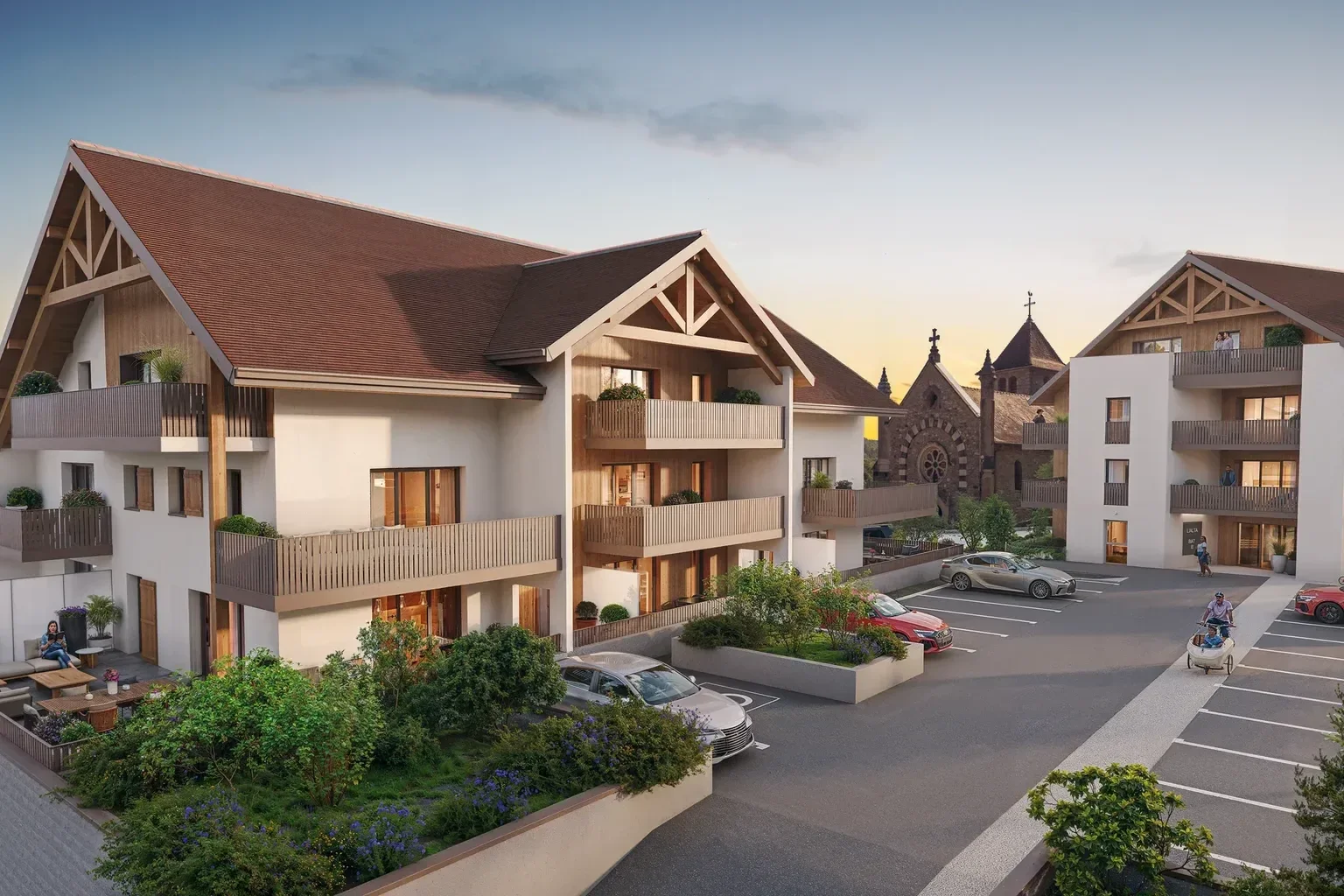
In short: a 3D architectural rendering is an image computed from the digital model of an unbuilt project. It shows façades at eye level, layout from the air and the project in its site, first for the building permit, then for sales.
A new development is sold before it exists. To present it to a local authority, to partners or to buyers, a developer needs images that show the building as it will be, in the street and neighbourhood it will belong to. That is the role of 3D architectural rendering.
This guide is for property developers and their teams. It explains what a 3D architectural rendering is, how an eye-level exterior view differs from an aerial view, how to show a project in its site, which files to provide, and how the same images serve the building permit application (permis de construire) and then the sales campaign.
What is 3D architectural rendering?
A 3D rendering is an image calculated from a digital model of the project. The building is modelled from the plans, then materials, light, planting and surroundings are added before the image is computed. You will also hear CGI or 3D perspective: these terms describe the same kind of visual, seen from the technical or the practical side. Our article what is CGI in real estate covers these notions.
In a residential development, 3D architectural rendering is mostly used for the outside: façades, surroundings, courtyards, aerial views and site integration. Interiors are a different exercise, covered in our guide to interior 3D rendering.
An image, not a photograph
A 3D rendering shows a project that has not been built. Nothing is captured: every element in the image is modelled or added. Its accuracy therefore depends entirely on the source documents and on the approvals made during production.

Exterior rendering and aerial view: two viewpoints, two uses
Both images come from the same model, but they answer different questions.
Exterior rendering (eye level) | Aerial view | |
|---|---|---|
Viewpoint | A passer-by, from the street or the garden | From above, as from a drone |
What it shows | Façades, materials, entrances, balconies, atmosphere | Layout, volumes, access, green spaces, neighbours |
Question it answers | "What will my building look like?" | "Where is the development and how is it organised?" |
Common uses | Site hoarding, brochure, listings | Presentations to local officials, sales plan, development page |
Eye-level exterior 3D rendering
This is the reference image of a development. The framing follows a real viewpoint, usually from the public space, and the lighting is chosen to show the façades at their best: daylight for legible materials, dusk for atmosphere and lit windows.
The aerial view
It gains height to show what a ground-level view cannot: how a block is organised, its relationship to neighbouring buildings, paths, parking and gardens. For a multi-building scheme or a housing estate, it is often the image that makes the project clear at a glance. It can be paired with a 3D site plan, which makes individual units easier to locate.

Showing a project in its site
Site integration means showing the project in its real surroundings: the existing street, neighbouring buildings, terrain, trees and landscape. Two techniques exist. A photomontage places the modelled building into a photograph of the site taken from a precise spot. Modelling the surroundings rebuilds them in 3D, which allows any viewpoint, including aerial ones.
Either way, the image must stay faithful: the building's scale, its height relative to its neighbours, and whether existing trees are kept or not.

Which files should you provide for a 3D architectural rendering?
The quality of a rendering depends first on what the developer and the architect provide. Gather the following before production starts:
- Plans: site plan, floor plans, elevations and sections, as PDF and ideally DWG;
- The architect's 3D model, if there is one: the team can start from it rather than remodelling the building;
- Materials and colours: descriptive notice (notice descriptive), façade schedule or references for cladding, windows and railings;
- Landscaping: landscape plan, planned species, fences, roads and parking;
- Site: address, photographs of the plot and its surroundings and, for site integration, the desired camera positions;
- Expected views: a list of images with, for each one, the viewpoint, the atmosphere (day or dusk) and the target medium.
Questions about the rendering tools themselves are covered in our guide to 3D rendering software.

From building permit to sales
A French building permit application includes a graphic document showing the project in relation to neighbouring buildings and the landscape, for example a photomontage (service-public.fr, building permit, in French, accessed 3 November 2026): a faithful site-integration rendering can fulfil this role. Once the permit is granted, the same model feeds the sales material, from 3D renderings to the orbital 3D model, the virtual tour, 3D animation and 3D configurators. How the image changes between these two stages is covered in detail in our article on architectural 3D rendering from planning to sales.
Sales images are not contractual: ANIL, the French national housing information agency, points out that advertising documents have no contractual value (ANIL, buying off-plan, in French, accessed 3 November 2026). They must nonetheless remain consistent with what will be delivered.
Checks before releasing a 3D rendering
- Façades, colours and windows match the current plans and descriptive notice;
- the building's height and scale are right relative to its neighbours;
- the planting shown matches the landscape plan, at a realistic stage of growth;
- elements outside the project (neighbours, roads) are faithful to what exists;
- every medium carries the "non-contractual image" notice (image non contractuelle);
- the architect has approved each view.
One 3D model for every medium
3D architectural rendering is only as reliable as the documents it starts from and the approvals given along the way. Building a complete model from the start, exteriors and surroundings included, means it can later be turned into renderings, an orbital model, a virtual tour or a film without starting over.
VIZION STUDIO produces your exterior renderings, aerial views and site-integration images from your plans or your architect's 3D model, then adapts the same model for every sales medium. Discover our 3D rendering service and contact us with your plans and the list of views you need.
3D services to bring your project to life
Preparing a property launch or an architectural presentation? Explore deliverables and examples relevant to this topic.
FAQ on 3D architectural rendering
What is a 3D architectural rendering?
It is an image calculated from a digital model of a building project. The building is modelled from the plans, then materials, light, planting and surroundings are added. It shows a building that has not yet been built, as designed.
What is the difference between an exterior rendering and an aerial view?
An exterior rendering is taken at eye level, from the street or the garden: it shows façades, materials and atmosphere. An aerial view is taken from above: it shows the layout, volumes, access and green spaces. Both come from the same model.
Which files are needed for a 3D architectural rendering?
The plans (site, floors, elevations, sections), the architect's 3D model if available, material and colour references, the landscape plan, photographs of the site and a list of expected views with their atmosphere and target medium.
Can a 3D rendering be used in a French building permit application?
Yes. According to service-public.fr, the application includes a graphic document showing the project in relation to neighbouring buildings and the landscape, for example a photomontage. A faithful site-integration rendering can fulfil this role, to be confirmed with the project architect.
Is a sales rendering contractual?
No. ANIL, the French national housing information agency, states that advertising documents have no contractual value: the description attached to the contract prevails. Sales images should still remain consistent with what will be delivered and carry a non-contractual image notice.
Give your project the images that will sell it
Get your first 3D image within 72 hours. Custom quote, no commitment.