
3D site plan: when to commission one for a development or a subdivision
Consultation, permit, sales launch, sales: the moments when a 3D site plan becomes useful, the case of subdivisions and the documents to provide.
By David Dana
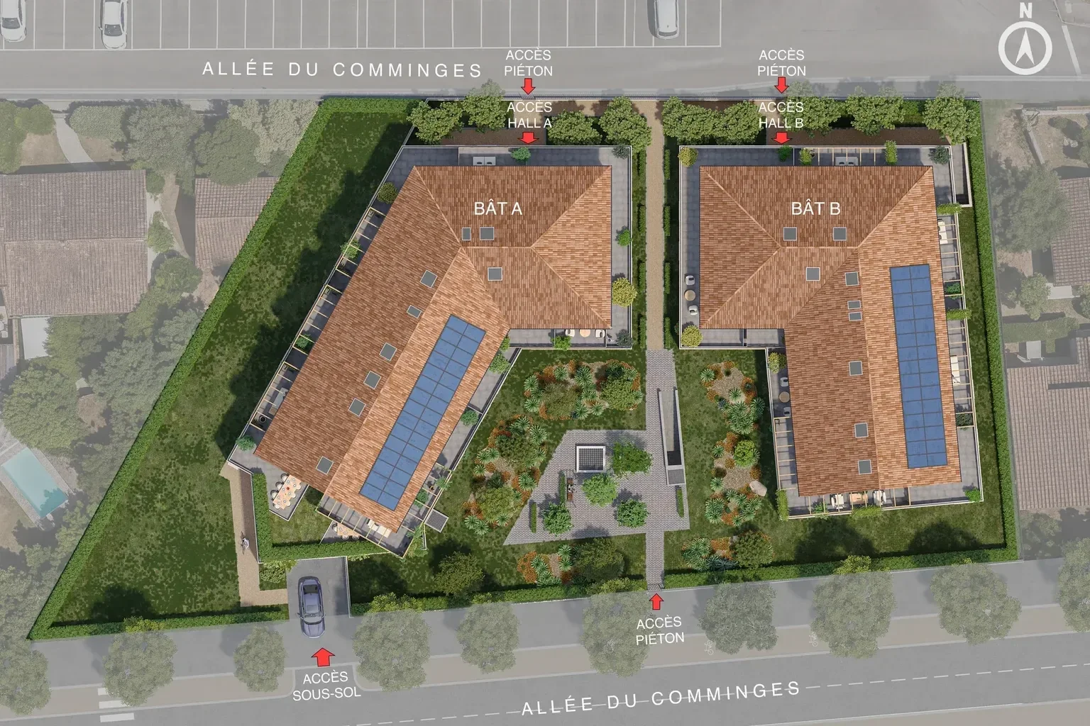
In short: a 3D site plan is worth commissioning as soon as the layout of a site has to be understood by people who do not read drawings: elected officials and residents during public consultation, the people involved in the permit application, then buyers at the sales launch and throughout the sales period. For a housing development, it shows the buildings, access points, parking and landscaped areas; for a subdivision (lotissement in France), it also shows how the plots and roads are laid out, with houses that remain hypothetical layouts. It accompanies the regulatory documents and never replaces them.
Every project has a site plan: in France, it is one of the planning application documents, drawn in two dimensions, dimensioned and made to be assessed. Its 3D version meets a different need: making the site understandable to people who are neither architects nor planning officers. So the question is not whether a site plan is needed, but when a three-dimensional view becomes useful, and for whom.
This article goes through those moments, then what changes between a housing development and a subdivision, and what to provide. To prepare the order itself, see our guide to briefing a 3D site plan.
What a 3D site plan shows
A 3D site plan is an aerial, three-dimensional view of a whole development: the buildings in place, access points, circulation, parking and green spaces, within their immediate surroundings. It is modelled from the site layout drawings and the documents provided by the project team.
Where a 2D plan requires you to know its graphic conventions, the 3D view is understood at a glance: you see the height of the buildings, where the gardens are, the route from the site entrance to the lobby. Labels can be added, such as building names or pedestrian and vehicle entrances.
When it is useful
During public consultation and discussions with the local authority
Before the permit is filed, the project is presented to elected officials, to council departments and sometimes to local residents. A 3D site plan shows them the layout, the volumes and the treatment of the surroundings better than a dimensioned drawing. It helps discuss what matters to them: where the buildings sit in relation to their neighbours, the access points, the share of planted areas.
Around the permit application
The application has its own graphic documents. For a development permit (permis d'aménager), the French public service website lists the location plan and the overall layout plan (plan de composition d'ensemble) and, where there is construction, the site plan, the elevation and roof plan and the section (service-public.fr, permis d'aménager, in French, page checked on 13 February 2026, consulted on 19 November 2026). A 3D site plan replaces none of these: it is a presentation image that helps explain the project around the application, not one used to assess it.
At the sales launch
This is often when it becomes essential. On the development page, in the brochure or on a hoarding, it gives the overview before the renderings and floor plans: where the residence is, how you get in, where you park, where the gardens are. Buyers need this reading of the site before they look at a flat or a house.
During sales, to locate units
In an appointment, the sales adviser starts from the site plan to locate the unit: this building, this stairwell, garden side or street side. With building or unit numbers as labels, they answer layout questions without opening the dimensioned plan. If the development also has an orbital 3D model, the site plan remains its fixed version, printable and immediate.

Housing development or subdivision: what changes
For a housing development
In an apartment scheme or a group of houses, the developer builds the whole project. The 3D site plan shows buildings designed by the architect, their entrances, parking, and shared and private outdoor spaces. For a scheme of houses, it helps read how the plots and gardens are arranged.
For a subdivision
In France, a subdivision (lotissement) is defined by the public service website as a development operation "creating several building plots or gardens, governed by subdivision regulations" (« créant plusieurs terrains à bâtir ou jardins, encadrée par un règlement de lotissement », service-public.fr, in French, consulted on 19 November 2026). The developer sells plots; the houses are often built later by the buyers. The 3D site plan of a subdivision therefore focuses on the plot layout, roads, paths and shared spaces.
Any houses shown on it are only hypotheses. The French planning code even lists, among the documents of the development permit for a subdivision, "a graphic document showing one or more hypothetical layouts of the buildings" (« un document graphique faisant apparaître une ou plusieurs hypothèses d'implantation des bâtiments », article R. 442-5 of the French planning code, in French, consulted on 19 November 2026). A 3D view showing houses must say so clearly, so that no buyer mistakes a silhouette for a finalised design.
For a home sold off-plan within a subdivision, the French national housing information agency (ANIL) states that the documents appended to the sale contract must include, where they exist, the subdivision specifications and regulations, as well as the plan of the whole development (ANIL, buying off-plan, in French, consulted on 19 November 2026). The 3D site plan makes the whole easier to read; it replaces none of these documents. Our article on VEFA off-plan sales in France explains how these sales work.
What to provide
The earlier the request, the more provisional the documents. A 3D site plan is therefore commissioned once the layout is stable enough not to be redrawn at every meeting. To start, you will generally need:
- the up-to-date site layout or overall layout plan, with the site boundaries;
- the elevations and heights of the buildings or, for a subdivision, the siting and height rules of the regulations;
- the landscape plan, even if provisional, with the planting to be kept or created;
- the numbering of buildings or plots, identical to that of the sales documents;
- the labels to show: access points, parking, paths, shared spaces.
If something is missing, it is flagged at the scoping stage rather than invented. The level of detail, labels and formats are set in the quote. Our team can also start from your existing 3D model. Our briefing guide includes a template to fill in.

Commissioning the 3D site plan at the right time
A 3D site plan is justified as soon as people outside the project need to understand how the site is organised: during consultation, around the permit, at the sales launch and then during sales. In a subdivision, it mainly shows the plot layout and the shared spaces, and any house shown remains a hypothesis. In every case, it complements the regulatory documents and those given to the buyer, which alone are binding.
VIZION STUDIO produces your 3D site plans from your layout documents, for your presentation files and your sales campaign. To find out more, see our 3D site plan page or contact us with your site layout plan.
3D services to bring your project to life
Preparing a property launch or an architectural presentation? Explore deliverables and examples relevant to this topic.
Frequently asked questions: when to commission a 3D site plan
When should a 3D site plan be commissioned?
As soon as the layout is stable enough and people outside the project need to understand it: during consultation, around the permit, then at the sales launch and during sales. Too early, the documents are still changing; too late, it is missing from the first appointments.
Does a 3D site plan replace the site plan in the permit application?
No. The permit application has its own graphic documents, dimensioned and regulatory. A 3D site plan is a presentation image that helps explain the project, without replacing any of these documents.
What does a 3D site plan show for a subdivision?
Mainly the plot layout, roads, paths and shared spaces. Any houses shown are only hypothetical layouts, as the French planning code itself provides for the development permit: the view must say so clearly.
Which documents are needed for a 3D site plan?
The up-to-date site layout or overall layout plan, the elevations and heights (or the rules of the subdivision regulations), the landscape plan, the numbering of buildings or plots and the list of labels to show. Anything missing is flagged at the scoping stage.
What is the difference between a 3D site plan and an orbital 3D model?
A 3D site plan is a still image of the whole site, easy to print and share. An orbital 3D model is interactive: users rotate the development, cut away floors, filter units and see the
Give your project the images that will sell it
Tailor-made quote, no commitment.